
Reconsidering Richmond: Rethinking the way we inhabit the town centre : Cohohui Aotearoa Collective Housing Conference 2025
Hannah Mangin
In April 2025, I had the opportunity to present my Master of Architecture research thesis at the Cohohui Aotearoa Collective Housing Conference, hosted by the Housing Innovation Society at the Ara Institute of Canterbury. The conference, themed “The Future of Housing”, provided a platform for academic and professional discourse around housing innovation, urban regeneration, and sustainable community design.
The research titled “Reconsidering Richmond: Rethinking the way we inhabit the town centre”, focused on how suburban town centres affected by urban sprawl can be revitalised through housing density and public amenities.
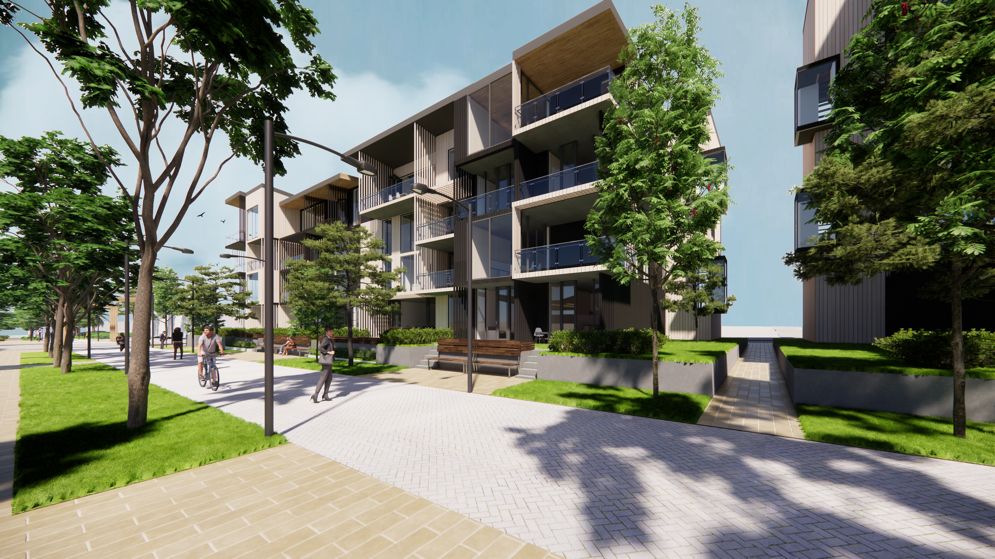
Exterior Perspective
The research responds to the rapid suburban expansion of Richmond, Tasman as just one New Zealand example where urban sprawl has been prevalent over the last 10-15 years. Urban sprawl has developed larger suburban areas further away from the town centre. This has caused the reliance on the car to reach local shops and Nelson's town centre creating dormitory suburbs. Resulted in low density developments, car dependent environments, and a lack of cohesive public spaces.
Richmond's urban form has limited walkability, underutilised civic facilities, and a scarcity of medium-density housing options. This combination has contributed to a town centre that lacks vibrancy, identity, and accessibility. To combat this the research explored strategies for densifying the town centre while simultaneously enhancing social, civic and environmental amenities.
This posed the question: “How can dense housing and public amenities regenerate the public realm?”
This was investigated through three objectives:
1. Increase density – will be achieved through providing high-quality dense housing in the town centre of Richmond. Increased density brings the economics of scale making infrastructure upgrades viable.
2. Improved amenities – Amenities that are missing in Richmond will be integrated and complement those that are predicted to be lost due to sea level rise in Nelson. The increased density will encourage amenities to stay open beyond the 9-5 workday.
3. Improve walkability – With Richmond’s urban environment being designed to accommodate the car it has resulted in an unpleasant and unsafe walking environment.
As a result, these three objectives aim to reduce the reliance on the car in turn GHG emissions and improve the energy and life in the town centre of Richmond.
Research Methodology
This research implements the methodology of design-led research. This allows the research to contain both an iterative and reflective process. The methodology of design research can be seen through Jane Rendell’s approach:
“Instead of posing a research question and then finding answers. In design research, the process operates through generative modes producing work at the outset that may be reflected upon later (Rendell, 2013).”
The two main techniques that were used over the course of the research:
Experimental - Iterate and test ideas to look at alternative ways of achieving aspects such as increased density, urban amenities, and housing quality.
Logical argumentation - A process of critically reflecting upon and establishing evidence of the research question through the design process.
An investigation into key precedents were introduced at the start of each design phase to inspire the phase ahead. This design-led research was developed through iterations over six design phases, to create a robust developed design. Key tools aiding this process include model making, sketching, digital modelling, and overlays. The methodology encouraged a reflective process at the conclusion of each design phase, allowing me to refine strategies based on observed strengths, weaknesses, and potential for real-world application.
Rethinking Urban Density: A Human-Centered Approach
The research was heavily inspired by global urban design principles, particularly the "15-Minute City" concept. This idea, proposed by Carlos Moreno, aims to create human-scale cities where all essential services—work, shopping, healthcare, and recreation—are within a 15-minute walk or bike ride from home. This model offers four main benefits: it boosts the local economy, creates a stronger sense of community, improves health and well-being, and reduces transport emissions. The current low-rise nature of Richmond (mostly one or two-story buildings) is not suited to a compact, walkable model. I believe the solution is not to build tall, anonymous high-rises, but to strategically increase density in a way that respects the human scale of the town.
This approach aligns with the ideas of urbanists like Jan Gehl, who argue that the success of urban design should be measured by the quality of life it offers to people. As he puts it, the built form must support everyday life, encouraging social interaction and a sense of community.
Beyond the Car: Creating Place and Community
To counter the "placelessness" caused by modern urban sprawl, the research drew on the work of thinkers like Ray Oldenburg and Edward Relph. Oldenburg’s concept of the “third place”—an informal gathering space outside of the home and work—is a key element of a healthy community. The research shows that suburban sprawl, with its car-dependent lifestyle, has eliminated these opportunities for spontaneous social connection.
The research also drew upon the principles of critical regionalism, a design philosophy that resists generic, globalized architecture. This approach argues that architecture should be rooted in its local context, responding to climate, topography, and the unique culture of a place. For Richmond, this means creating designs that reflect the local landscape and community identity, rather than imposing a "cookie-cutter" design on its urban fabric.
The Design Solution: A Clustered Hub
The final proposed design consolidates a clustered hub around Richmond’s Sundial Square, and intended for a sequential phased development over thirty years. The research focused on the short-term period which involved three programs: a new library, medium-density housing, and integrated green spaces.
The Housing Precinct: a dense, multi-unit residential development, testing modular apartment typologies, walk-up building heights, and hierarchical outdoor spaces to balance privacy, flexibility, and communal interaction. The design demonstrated that densities significantly higher than existing suburban subdivisions (71dph) up to 144 dwellings per hectare could be achieved without compromising spatial quality. The design emphasised the importance of orientating apartments to capture natural light, green buffers, and situating public amenities strategically to create active street edges. This phase highlighted the critical interplay between housing typologies, human scale, and the quality of life for residents, reinforcing that densification need not equate to reduced liveability.
The Civic Precinct: This phase focused on reimagining the local library as a modern "knowledge hub." integrating flexible spaces, makerspaces, and community meeting areas. This phase emphasised the evolving role of libraries as “third places” where social interaction, learning, and community engagement occur beyond home and work. Design tactics included maximizing natural light, establishing double-height public spaces, and enabling flexible programming to respond to population growth and technological change. More than just a place for books, this space would become a flexible, multi-purpose community centre. This design reflects the growing need for public buildings to act as vibrant third places that foster social connection and learning.
The Landscaped "Green Spine": To improve walkability and pedestrian connectivity, a landscaped green belt was proposed extending from Sundial Square - the existing town square and only desirable green space in the town centre. This "green spine" would create visual and social links between housing, commercial areas, and civic facilities to improve pedestrian connectivity, enhance biodiversity, and soften the car-dominated environment. Design tactics for the landscaped belt included visual surveillance through commercial activation, biodiversity enhancement with native plantings, and the introduction of wayfinding interventions and destination points to create a layered and engaging pedestrian experience.
Projecting ahead to the medium- and long-term phases (outside the scope of the research) anticipated the inclusion of a Town Hall, market spaces, and community art galleries.
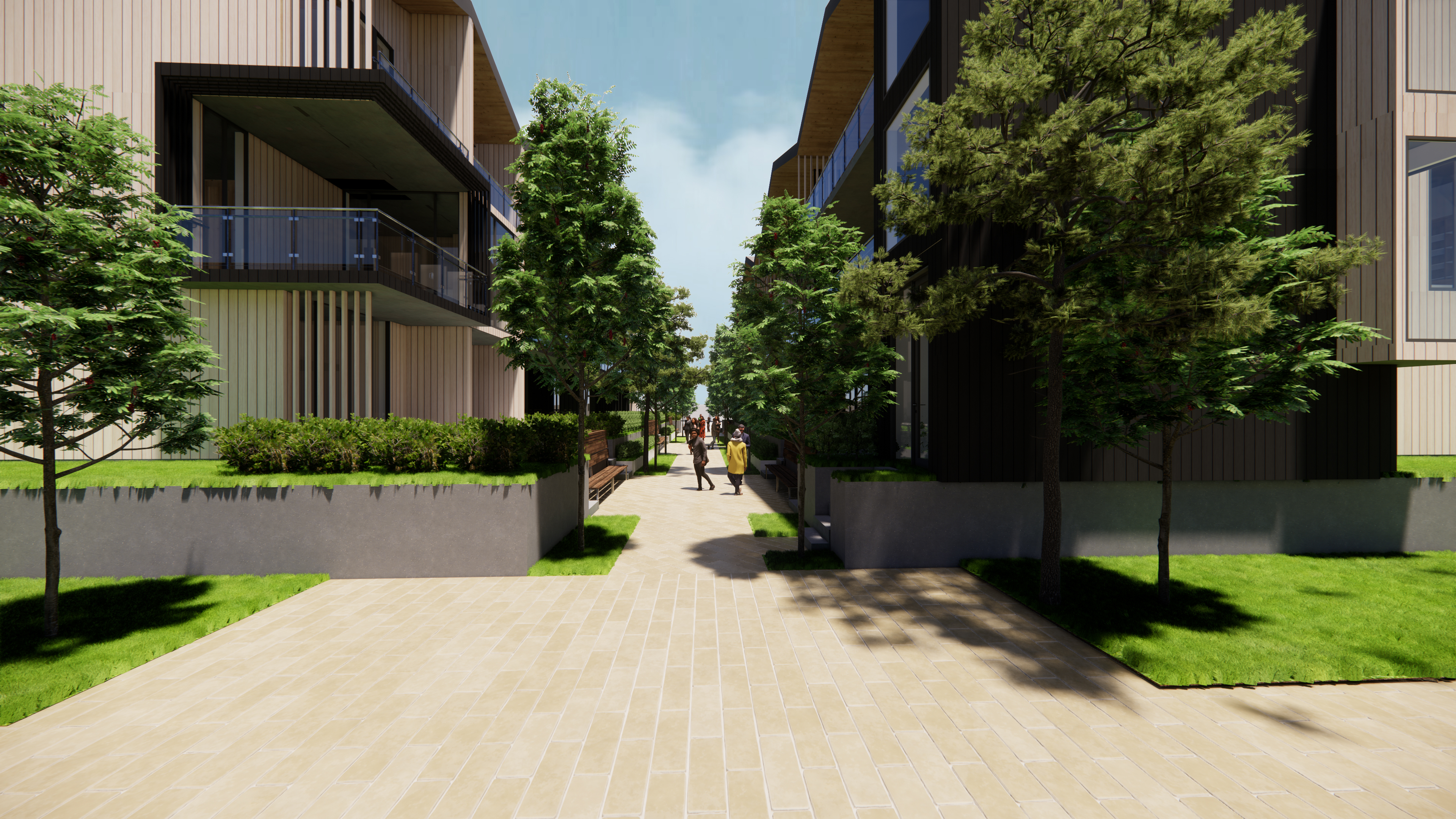
Exterior Perspective
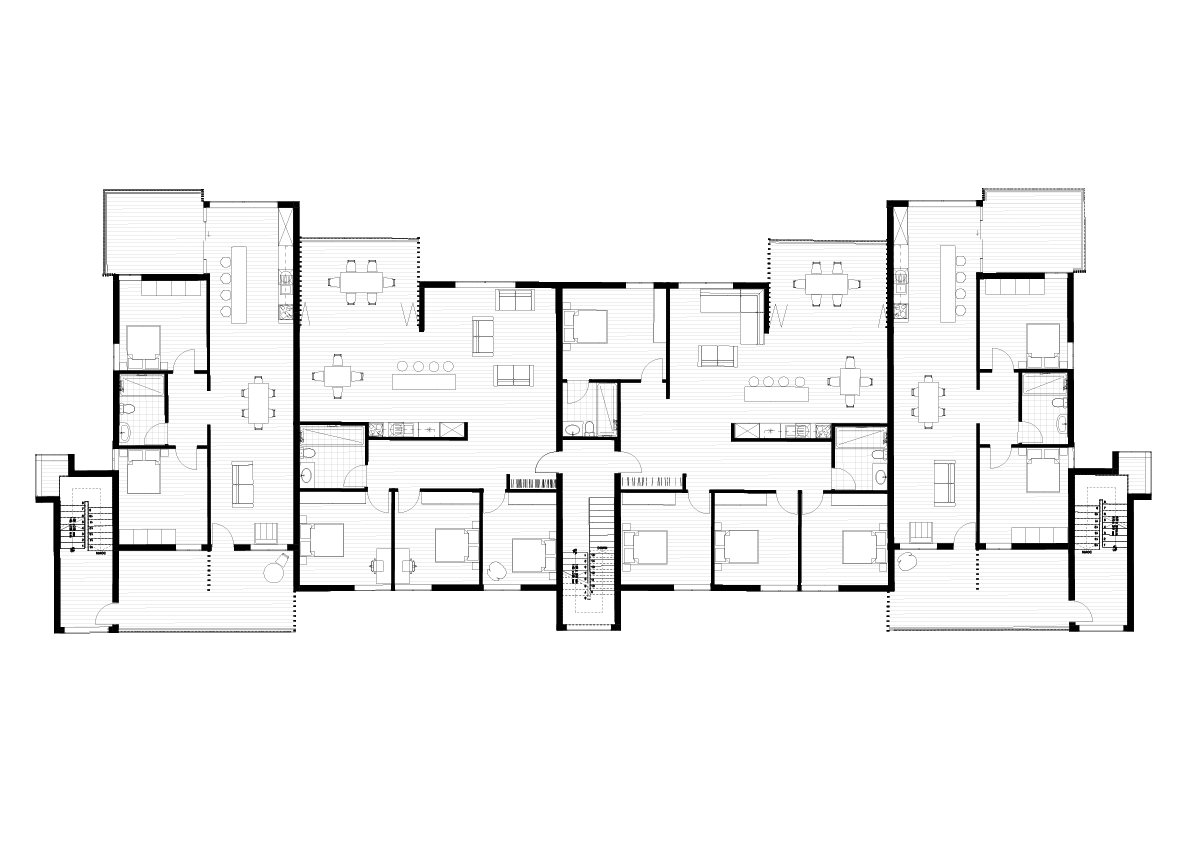
Cohousing Plan
A Blueprint for the Future
The research offers a clear blueprint for urban regeneration in New Zealand's suburban town centres. It shows that we can address urban sprawl and build resilient, sustainable communities by thoughtfully increasing housing density, improving amenities, and creating a desirable walking environment. The design illustrates that higher densities, when planned with care, do not reduce the quality of life but can, in fact, enhance social interaction, identity, and environmental performance.
This is a critical architectural response to some of our most pressing issues. The negative consequences of unchecked urban sprawl are already clear: town centres lack walkability, public facilities are underutilised, and community vibrancy is diminished. With the Tasman District's population projected to grow significantly, the pressure to find more housing and improve infrastructure is urgent. The 2022 floods in Nelson serve as a stark reminder that a strategic "urban reshuffle" is a necessity, not just a future possibility.
This design for Richmond's urban regeneration serves as a case study for other New Zealand towns facing similar issues. This work contributes to a broader discussion about the future of housing and urban development in Aotearoa, showing that with smart design, we can create places that are not only more efficient but also more human, connected, and truly livable.
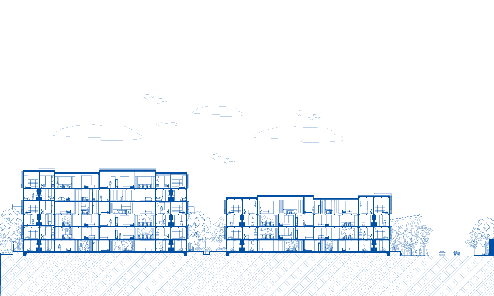
Longitudinal Section
All images have been provided by the Author